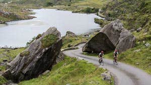
The Ring of Kerry Cycle Route is in an area known throughout the world for its archaeological treasures, breathtaking scenery and charming hospitality. The route travels along quiet country roads where possible and passes through all the main towns and villages along the way.
The entire journey is 216km (134 miles) with 74km of the route on the main road and 143km of the route on minor roads.
The route should ideally be cycled in a clockwise direction for safety and spread over a week in order to fully appreciate the relaxing atmosphere and magnificent variety of scenery. Cyclists should remember that some sections of the route are high and exposed and even in the summer months they should take note of the weather forecast and take suitable clothing and supplies.
The Ring of Kerry Cycle Route is divided into seven sections. The route starts in Killarney but of course it can be joined at any point.
(1) - Killarney to Kenmare - 42km (26 miles)
13km main road, 29km other roads.
Elevation range 50m -200m.
OSI Discovery Series Maps Sheet 78.
(2) - Kenmare to Sneem - 30km (19 miles)
13km main road, 17km other roads.
Elevation range 60m- 150m.
OSI Discovery Series Maps Sheets 78, 84.
(3) - Sneem to Waterville - 35km (22 miles)
28km on main road, 7km other roads.
Elevation range 70m-200m.
OSI Discovery Series Maps Sheet 84.
(4) - Waterville to Portmagee - 29km (18 miles)
3km main road, 26km other roads.
Elevation range 50-250m.
OSI Discovery Series Maps Sheet 83
(5) - Portmagee to Caherciveen via Valentia Island - 16km (10 miles).
1km main road, 15km other roads.
Elevation range Sea level – 90m.
OSI Discovery Series Maps Sheet 83.
(6) - Cahersiveen to Killorglin - 42km (26 miles)
10km main road, 32km other roads.
Elevation range 50m-100m.
OSI Discovery Series Maps Sheets 78, 83.
(7) - Killorglin to Killarney - 22km (14 miles).
6km main road, 16km other roads.
Elevation range 20m -50m.
OSI Discovery Series Maps Sheet 78
